Tiger Shark Data Analysis

Few weeks ago I was at a movie screening and panel discussion about tiger sharks at the Museum of Art of Fort Lauderdale. During the reception I talked to the main presenter — prof. Shivji — and some of his students about the shark data they have and boldly offered to do data mining on it. My angle was, “ok, let’s drop the usual statistics with its inductive jumps and use the more straightforward of approach data mining”. I asked what is the volume of the shark data, and it turned out only eleven shark are followed. This diminished my enthusiasm, but may be they had lots of data for each shark.
So I grabbed the data available at the web site “Track Your Tiger Shark”, and started doing plots, histograms, and harvesting of weather and elevation data for the sharks locations at the times they showed up. The location and time of the tagged sharks are recorded when their fins are above the water surface. (I.e. the tracking devices on their fins are above the surface.)
I worked mostly with the sets “Bermuda 2009” and “Bermuda 2010”. I used the Google elevation service to get the depth of the water at the shark locations, and Mathematica’s WeatherData interface for air temperature and wind direction and speed.
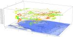
I would not say that the data matchings, various clusterings, and plots uncovered something new. Except one, all attempts for correlation and law discoveries were either hard to interpret (probably meaningless), or easy to explain. For example, in the 3D histogram of the shark locations we can see that the sharks would most likely spend their time in shallow waters around the islands where food is easier to find.

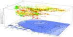
I also plotted histograms, “trajectories”, and polar plots of depth, speed, average time to show up, and few others. (See the gallery below)
The most interesting find from all this activity is illustrated in the plot below — the sharks prefer to swim against the wind. For each shark I calculated its assumed direction of swimming and compared it to the wind direction at that time and geographical point. The comparison is done by calculating the cosine of the angle between the wind and shark directions. (If the cosine is -1, the directions are opposite; if it is 1 the directions coincide.) When we make this comparison we need to also look at the wind velocities and the time intervals between two consecutive points of the sharks showing up. I made histograms of the intervals but did not make correlation study with the cosines. (Well, not yet.)
I assume at the surface the water has the same direction as the wind. I have two conjectures why sharks would prefer swimming against the wind.
1. Other (smaller) fish follows the water direction, and, hence, it is easier to catch.
2. It is easier to breathe.
To clarify the second point, let us note, that in order to breathe most shark species have to constantly swim forward or, if still, face a current in order the water to flow over their gills. Although I am not sure is the respiratory system of the tiger sharks like this, it seems that they might prefer facing the current especially if they are younger — note the plots of the juvenile sharks. (They have “juvenile” next to their names.) The sharks from the “Grand Cayman” data set disprove the conjecture — see the row before the last. The last row of plots should be ignored because for too many of the shark locations the wind data is missing.

In the gallery you would find images of a 3D shark location histogram, the space-time trajectory of one of the sharks, the space-time (3D) and space (2D) trajectories of all sharks, and a table of plots of sorted cosines of wind direction minus shark direction for each shark.


Hi Anton,
I really like your presentation. I tried to reproduce it but I cannot find the data on the web site you mentioned. Can you provide the link to the data?
Regards
Thomas